Rivers Basins Mapping in QGIS
A [Draft] Tutorial (29 images take time to load)
Wendy Anthony
07/09/2021
1 Get Spatial River Data
GloRiC Global River Classification Database:
https://hydrosheds.org/page/gloric
* Technical Documentation
1.1 Basin Data
HydroBASINS (polygons) >> Customize (with lakes) >> North America and Caribbean >> hybas_lake_ar_lev01-12_v1c.zip >> hybas_lake_ar_lev12_v1c.zip >>
Request download >> add email address >> an email will be sent with link to the download (e.g. 429 MB) >>
Unzip files
Fig 1: webpage

Fig 2: download choices

Fig 3: Download Request via email
1.2 GoRiC Rivers Data
GoRiC Global River Classification Database (lines) >> download River Reaches file >>
Unzip files 
Fig 4: GloRiC website

Fig 5: Data Download

Fig 6: Download zipfile page
2 Mapping Data Layers With QGIS
2.1 Add a base map layer using Quick Map Services
Quick Map Services tool icon >> Choose base map >> base map is added as layer >> zoom to area of interest
Fig 7: Choose Esri Satellite

Fig 8: Zoom to area of interest
2.2 Open data in QGIS
2.2.1 Add River Reach Vector Line Layer
Layer >> Add Layer >> Add Vector Layer >> Source Type: File >> Source: Vector Database > Browse for shape.shp file >> Add >> Close
Fig 9: Add River Reach Vector Layer

Fig 10: Choose shape.shp file

Fig 11: Add Layer and Close
2.2.2 View River Reach Data Layers and change colours
change colour of river layer lines >> double-click layer to open Layer Properties >> Symbology >> Color > choose from dropdown arrow >> Layer rendering > Opacity > 100% > Apply >> OK
Fig 12: Show River Data Layer

Fig 13: Change colours of River line data

Fig 14: View New River line colour
2.2.3 Add River Basin Vector Polygon Layer

Fig 15: Add River Basin data layer

Fig 16: View River Basin data layer
2.3 Select Features for Area of Interest and Save New shape.shp files
- for both River Reaches and River Basins to reduce number of features to map
- keep both layers visible to ensure the same area of features are chosen for each layer
zoom in to area of interest >> Select Feature by polygon tool >> careful click and draw a polygon shape around area of interest >> double-click to complete polygon >> after completeing a polygon, right click within polygon >> selected features are now coloured yellow
Fig 17: zoom into area of interest

Fig 18: Select Feature by polygon tool

Fig 19: Draw polygon to Select Features

Fig 20: Export to Save Select Features
2.3.1 Save selected features as new shapefile.shp
Right click layer >> Export >> Save Selected Features As >> Format: ESRI shapefile >> Filename: browse >> Geometry Type: Polygon >> check 'Add saved file to map' >> OK >> uncheck origin file layer >> remove original layer (right-click > remove layer)
Fig 21: Remove old layers
2.4 View River Reach and River Basins Data Layers and change colours
- done after selecting features for area of interest to reduce number of polygons to categorize
change colour of river basins polygons >> double-click layer to open Layer Properties >> Symbology >> Change from Single Symbol to Categorized >> Value: choose data value to categorize by >> Color Ramp: Random colors >> Classify >> Apply
>> Layer rendering > Opacity > 58% > Apply >> OK
Fig 22: Change colours of River Basins

Fig 23: Categorize River Basins by ID

Fig 24: Change to random colours of River Basins

Fig 25: Ensure Layer Draw Order with River Basins above River Reaches

Fig 26: Categorize River Reaches by Reach_ID
2.5 Change background base map to CartoDB Dark Matter mode
- hide layer for ESRI satellite map

Fig 27: Change base map to CartoDB Dark Matter mode
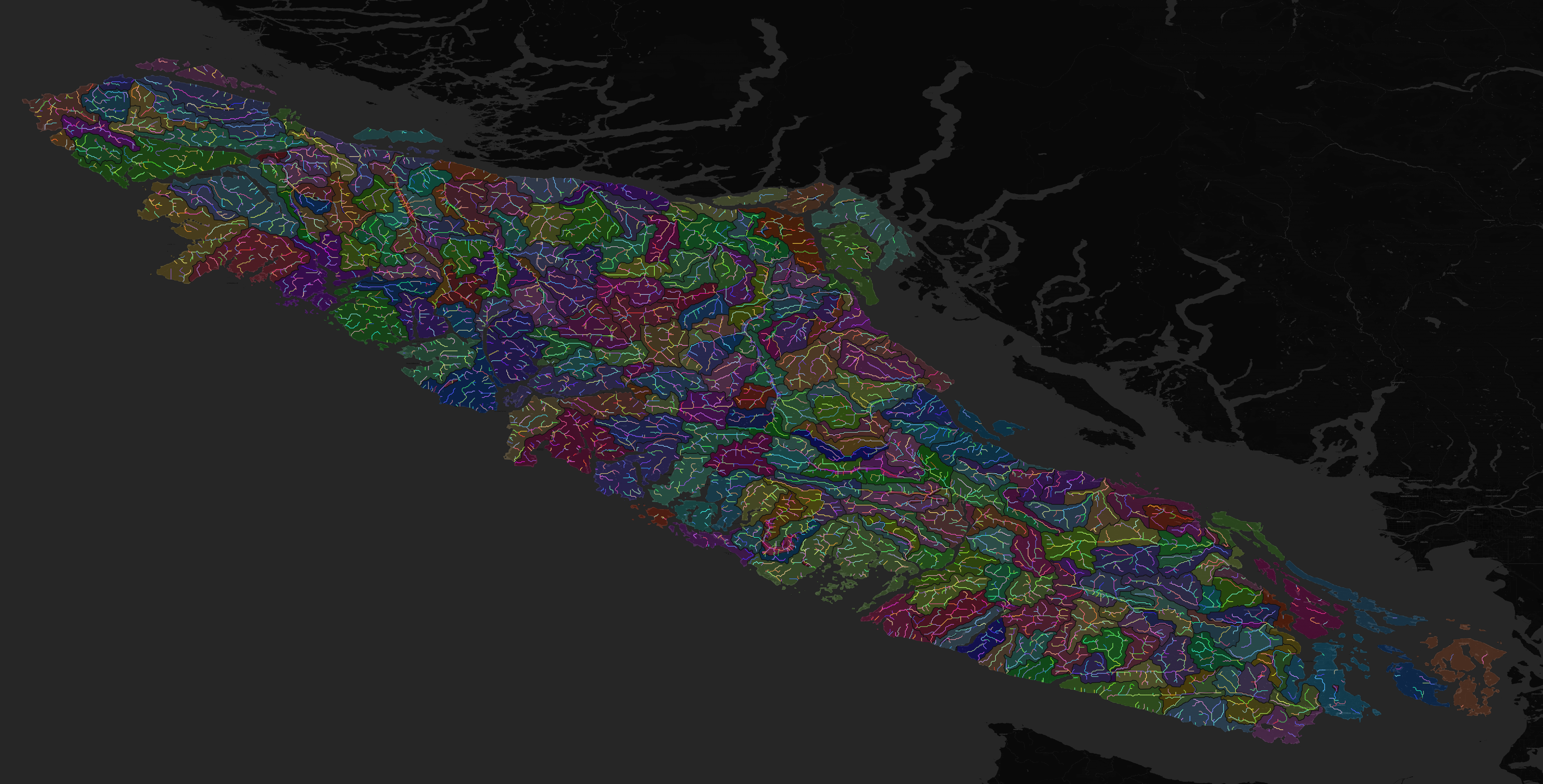
3 Completed map of Vancouver Island Watershed Basins and River Reaches
- Note: The Rivers Reach colours are different for each section due to categorizing by Reach_ID
- If Rivers were not categorized, they would all stay the same colour
- Because the Rivers Range layer is below the categorized Rivers Basin layer, the Rivers are the same colour within each basin, but each basin’s rivers become a subset of the basin’s colour

Vancouver Island Rivers and Watersheds
4 My River Watershed maps on the web
